
 The Comprehensive Everglades Restoration Project (CERP) is a monumental 30-year undertaking involving 18,000 square miles of South Florida and at an estimated cost of 7.8 billion dollars. The overall goal of the CERP project, which is spearheaded by the U.S. Army Corps of Engineers, Jacksonville District and the South Florida Water Management District, is to recapture the freshwater that flows unused from the manmade canals of Florida into the Gulf of Mexico. By doing this, the Corps and the Water Management District hope to restore the natural hydrology of the Everglades ecosystem, which has been altered by land drainage modifications throughout the twentieth century. Additionally, this will enhance freshwater supplies for both municipal and agricultural use in south Florida.
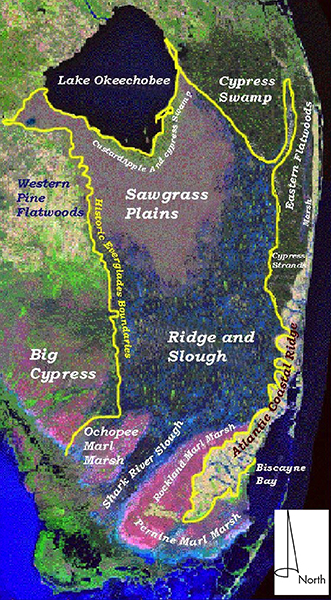
The CERP project area is a natural and cultural landscape that covers most of southern Florida and comprises some or all of 13 counties. The region features a number of micro-environments with different natural settings that influenced the distribution of cultural sites. The restoration projects cover large acreages and will impact cultural resources; therefore, in anticipation of these projects, the Corps requested that New South prepare an updated cultural resource survey strategy to more effectively isolate probability areas and locate sites in the region. The survey strategy is designed to have applicability to any project in the CERP project area and, because of its extensive geographic focus, to have benefits for both academic research and cultural resource management purposes.
The survey strategy prepared by New South included several parts: an overview and summary analysis of known cultural resources, an evaluation of past survey procedures, the identification of site probability variables, and the development of the region-wide survey approach. Florida survey and site data in GIS format were used, as were historic aerial photographs, maps, and other pertinent resources to create GIS data sets that depict site probability by sub-region. The use of GIS allowed different types of data to be visually layered upon one another. Work included 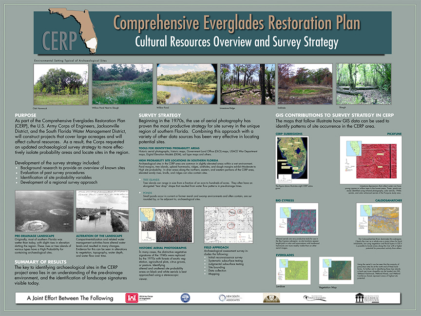 collaboration with the Florida Bureau of Archaeological Research, the Division of Historical Resources, Janus Research, and the Archaeological and Historical Conservancy, Inc. The CERP Survey Strategy will allow the Corps to design project scopes that are both cost efficient and effective.
In conjunction with the Corps, New South Associates presented a poster on the CERP project at the 2008 Greater Everglades Ecosystem Restoration (GEER) Conference and a poster session at the 2009 Annual Meeting of the Society for American Archaeology (SAA) illustrating the cultural resource aspects of the CERP project.